topography
US /təˈpɑ:grəfi/
・UK /təˈpɒgrəfi/
C2 高級
n. (u.)不可數名詞地形
I can see the topography of this land is hilly
影片字幕
紐約真的要沉沒了嗎? (Is New York really sinking? | BBC Global)

- Luckily, New York City has high topography.
我們需要確保的是,每項基礎設施都能容納和吸收水,這樣我們的百年下水道系統才能趕上並處理這些水。
- Luckily, New York City has high topography.
這些建築可以做些什麼呢?
奇洛李維斯但有「電單車」問題?| Tech Support | WIRED Japan (キアヌ・リーヴスだけど「バイク」について質問ある?| Tech Support | WIRED Japan)
- Topography.
地形。
- Topography, culture.
地形、文化。
抽乾海洋根本超難! (Draining The Oceans Is HARD)
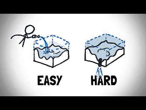
- The ocean has topography, so even if you put your drain in the deepest part of the ocean, eventually some of the water – actually, a lot of it – will get cut off from the drain and stick around as landlocked seas.
海洋是有地形的,所以即使你把下水道放在海洋的最深處,最終還是會有一些水--實際上是很多水--被下水道截斷,成為內陸海。
- The ocean has topography, so even if you put your drain in the deepest part of the ocean, eventually some of the water—actually, a lot of it—will get cut off from the drain and stick around as landlocked seas.
這將是一個令人頭疼的問題--你將不得不修建新的排水溝,或者挖掘巨大的溝渠,或者用巨大的海綿之類的東西拖幹海水。
80年後的廣島與長崎,有何不同? (80 Years After: What's the difference between Hiroshima and Nagasaki today?)
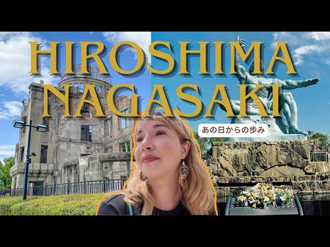
- The influence of Chinese and European cultures is immediately visible, and the city's topography sets it apart, built into the hills, layered and winding.
中國和歐洲文化對這座城市的影響一目瞭然,而依山而建、層層疊疊、蜿蜒曲折的地形也讓這座城市與眾不同。
- and the city's topography sets it apart, built into the hills, layered and winding.
您可以乘坐纜車到山上更高的位置觀賞夜景,但在酒店裡有很多位置供您欣賞夜景,無需爭搶空間,非常舒適親切。
葉門為何走向滅亡?阿曼又為何蓬勃發展? (Why Yemen is Dying & Oman is Booming)
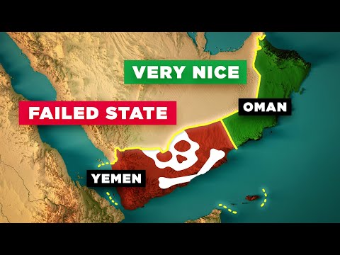
- And in addition to their similar rainfall levels and similar mountainous and desert topography, they both contain similar amounts of geological resources as well.
除了相似的降雨量和相似的山地、沙漠地形外,他們也擁有相似數量的地質資源。
- And, in addition to their similar rainfall levels and similar mountainous and desert topography, they both contain similar amounts of geological resources as well.
除了相似的降雨量和相似的山地、沙漠地形外,他們也擁有相似數量的地質資源。
多音束測深儀繪製海底地圖! (Mapping the seafloor with the Multibeam Echosounder)
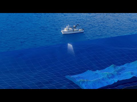
- First thing is that we pick our locations for all our deployments, including the sub dives based on the mathematical data, because that's where we will see the topography of the terrain of the seafloor.
首先,我們要根據數學數據來選擇所有部署地點,包括下潛地點,因為我們將在那裡看到海底的地形地貌。
- First thing is that we pick our locations for all our deployments, including the subdives, based on the bathymetric data, because that's where we will see the topography of the terrain of the seafloor.
是以,我們不想把著陸器放在會滾落的斜坡上。
海洋比你想像的更深!我們需要更好的海圖! (The Ocean Is Deeper Than You Think. We Need Better Maps.)

- If you look at Google Maps, you might think that we know the precise topography of all of this, but that's a lie.
如果你看看谷歌地圖,你可能會認為我們知道這一切的精確地形,但這是個謊言。
- If you look at Google Maps you might think that we know the precise topography of all of this,
如果你看看谷歌地圖,你可能會認為我們知道這一切的精確地形,但這是個謊言。
臺灣地理為何是一顆計時炸彈? (Why Taiwan's Geography is a Ticking Time Bomb)
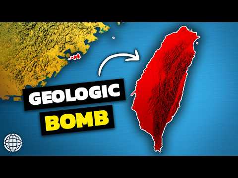
- This extreme topography dictates all life on Taiwan.
五大山脈如同脊樑般貫穿島嶼,其中中央山脈是最大的。
- This extreme topography dictates all life on Taiwan.
這種極端地形決定了臺灣上的一切生命。
9分鐘帶你搞懂所有主要的街道格局! (Every Major Street Pattern Explained in 9 Minutes)
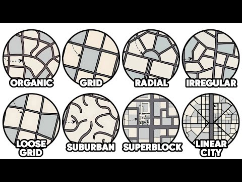
- When the city was founded, planners said, "Let's ignore the topography and impose the grid." The result?
城市創立時,規劃師說:「我們就無視地形,強加格子紋理吧。」結果呢?
- When the city was founded, planners said, "Let's ignore the topography and impose the grid." The result?
像九曲花街那樣的蜿蜒街道,40 度的坡度,以及電影《警匪大決鬥》中著名的追車場景。