用法解析準備中,稍後再回來看看
在 App 中使用完整體驗
隨時隨地學習,完整解析句子與用法
01:03
She took a brave step forward, leaving behind her comfort zone to chase her dreams.
單字片語
- brave
adj. 有勇氣的
- comfort zone
phr. 舒適圈
本句說明
a brave step 是名詞片語,其中 brave 是形容詞,修飾名詞 step,表示「勇敢的一步」。
forward 是副詞,修飾 step,表示「向前」。
整個片語作為受詞,回答 took(動詞) 的「什麼」——她邁出了勇敢的一步向前。
在 App 中使用完整體驗
隨時隨地查單字,掌握發音、詞性與用法
brave
US/brev/
UK/breɪv/
adj.勇敢的
v.t.勇敢地面對
A2 初級
在 App 中使用完整體驗
隨時隨地練習口說,立即獲得發音回饋
Try this speaking exercise.
試著跟著這句話練習。
80
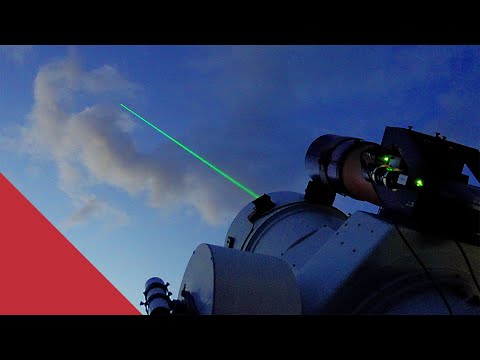
天文台為什麼都建在山上?天文台上的雷射儀解密(Why this observatory fires lasers at satellites)
0
Jeff Chiao 發佈於 2022 年 03 月 19 日好奇我們是如何精準追蹤衛星的嗎?這支影片將帶你深入了解「衛星雷射測距」(Satellite Laser Ranging)的迷人世界,看看英國的天文台如何利用雷射來測量衛星軌道,並在過程中學習進階詞彙!你將會認識地面站、雷射脈衝,甚至了解大氣延遲如何影響這些測量喔。
在 APP 上學習此影片!
在 VoiceTube App 中有針對影片更深入的練習方式唷!